Ten St. Petersburg neighborhoods from the city's own map, with ZIP codes, zoned high schools for 2026-27 and Zillow home values for August 2026.
Last checked Oct. 11, 2026. Sources: the City of St. Petersburg’s neighborhood association map and parcel map, © OpenStreetMap contributors, Pinellas County Schools’ School Zone Locator, the Florida Department of Education’s 2026 school grades, the Zillow Home Value Index (Zillow Research) and the Census Bureau’s QuickFacts.
St. Petersburg is a city of about 262,700 people, according to the Census Bureau’s 2020-2024 American Community Survey, on the southern end of the Pinellas peninsula, with Tampa Bay on the east and Boca Ciega Bay on the west. Interstate 275 runs north to south through it, with its I-175 and I-375 spurs ending downtown. The street grid is numbered from downtown: avenues run east and west, streets north and south, and the N, S, NE and SE suffixes tell you which quarter of the city an address is in.
Three things to know before you pick an area:
- City limits are irregular. A “St. Petersburg” mailing address can be in Gulfport, Lealman or another place outside the city. The Pinellas County Property Appraiser’s quick search shows which taxing district a parcel is in.
- ZIP codes cross neighborhoods. Zillow’s figures below are for a whole ZIP code, which usually covers several areas.
- School zones do not follow neighborhood or city lines. Pinellas County Schools zones by address. Some west-side areas are zoned for Boca Ciega High, which is in Gulfport. Check every address in the School Zone Locator.
What this means for you
- High schools: five of the 10 areas were zoned for St. Petersburg High in all our checks; the others were zoned for Lakewood, Northeast, Gibbs, Boca Ciega or Dixie M. Hollins High.
- Home values: Zillow’s typical value in August 2026 ran from $275,667 in ZIP code 33711 to $742,292 in 33701 among these areas; the citywide figure was $354,074.
- Coming up: the School Board is scheduled to vote Tuesday, Oct. 13, on the district’s Planning for Progress rezoning proposal for 2027-28.
The areas at a glance
| Area | Main ZIP code | Zoned high school, 2026-27 | Typical home value in that ZIP, August 2026 | Guide |
|---|---|---|---|---|
| Downtown | 33701 | St. Petersburg High | $742,292 | Downtown |
| Old Northeast | 33701, 33704 | St. Petersburg High | $742,292; $735,185 | Old Northeast |
| Snell Isle | 33704 | St. Petersburg High | $735,185 | Snell Isle |
| Crescent Lake | 33704 | St. Petersburg High | $735,185 | Crescent Lake |
| Historic Kenwood | 33713 | St. Petersburg High | $361,180 | Kenwood |
| Old Southeast | 33705 | Lakewood High (most), Gibbs High | $331,140 | Old Southeast |
| Childs Park | 33711 | Gibbs High (most), Boca Ciega High | $275,667 | Childs Park |
| Pinellas Point | 33712, 33705 | Lakewood High | $321,132; $331,140 | Pinellas Point |
| Shore Acres | 33703 | Northeast High | $398,232 | Shore Acres |
| Jungle Terrace | 33710 | Boca Ciega High or Dixie M. Hollins High | $379,341 | Jungle Terrace |
Home values are from the Zillow Home Value Index, a modeled typical value for the middle third of homes, not a sale price. Zoned schools are from addresses we checked in each area in the district’s locator on Oct. 11, 2026. More in our home prices guide and schools guide.
Map
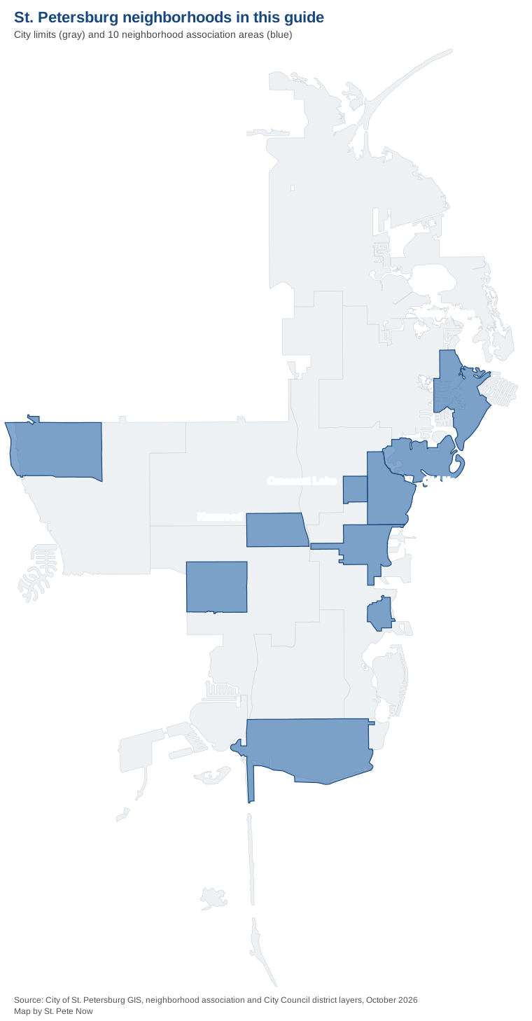
Map by St. Pete Now from the City of St. Petersburg’s neighborhood association and City Council district layers.
Downtown
The waterfront core, about 630 acres, mostly condo units, with the Pier, the museums and City Hall. ZIP code 33701; zoned for St. Petersburg High. Read the Downtown guide.
Old Northeast
Older houses and duplexes on a grid north of downtown, with a chain of bayfront parks. Nearly all of the North Shore National Register historic district is inside it. ZIP codes 33701 and 33704. Read the Old Northeast guide.
Snell Isle
Single-family homes on curving streets and canals across Coffee Pot Bayou, all in ZIP code 33704. Read the Snell Isle guide.
Crescent Lake
A small area of homes around Crescent Lake Park and Huggins-Stengel Field, zoned for Woodlawn Elementary and St. Petersburg High. Read the Crescent Lake guide.
Historic Kenwood
A grid of bungalows west of downtown, most of it a National Register historic district, with St. Petersburg High inside it. ZIP code 33713. Read the Kenwood guide.
Old Southeast
About 500 older homes, by the association’s count, between 4th Street South and Lassing Park on the bay. Mostly zoned for Lakewood High. Read the Old Southeast guide.
Childs Park
A large area of single-family homes west of 34th Street South, with a park, lake and sports complex and the Pinellas Trail. ZIP code 33711. Read the Childs Park guide.
Pinellas Point
The city’s southern tip, about 2,012 acres, with Lake Vista Park and Maximo Park. Zoned for Bay Point Middle and Lakewood High. Read the Pinellas Point guide.
Shore Acres
Waterfront homes on canals and bayous in the northeast, zoned for Shore Acres Elementary and Northeast High. ZIP code 33703. Read the Shore Acres guide.
Jungle Terrace
The far west side along Tyrone Boulevard, with Walter Fuller Park and Abercrombie Park. Split between Boca Ciega and Dixie M. Hollins high schools. Read the Jungle Terrace guide.
Comparing St. Petersburg with nearby cities
For taxes, schools, home values and city services in St. Petersburg, Gulfport, South Pasadena and St. Pete Beach side by side, see our city comparison. For moving basics, see our moving here guide and property taxes guide.
How we built this
- Which areas: the City of St. Petersburg’s neighborhood association map lists 89 associations with boundaries. We chose 10 active associations spread across the city that OpenStreetMap also names as places, and each area page follows that association’s boundary on the city’s map. Other registry areas, such as Riviera Bay, Disston Heights and Jungle Prada, are not in this guide.
- Homes and ZIP codes: counts of parcels inside each boundary from the city’s parcel map.
- Schools: 14 to 16 residential addresses per area checked in Pinellas County Schools’ School Zone Locator on Oct. 11, 2026, with 2026 grades from the Florida Department of Education.
- Home values: the Zillow Home Value Index for August 2026, by ZIP code and for the city.
- Places, stores and road distances: © OpenStreetMap contributors.
Frequently asked questions
What are the neighborhoods in St. Petersburg, Florida?
The city’s map lists 89 neighborhood associations. This guide covers 10 of them: Downtown, Old Northeast, Snell Isle, Crescent Lake, Historic Kenwood, Old Southeast, Childs Park, Pinellas Point, Shore Acres and Jungle Terrace.
Which St. Petersburg neighborhoods are zoned for St. Petersburg High?
In our address checks for 2026-27, Downtown, Old Northeast, Snell Isle, Crescent Lake and Historic Kenwood were all zoned for St. Petersburg High, which earned an A in Florida’s 2026 grades.
Do St. Petersburg school zones follow neighborhood lines?
No. Pinellas County Schools zones by address, and some areas are split. Old Southeast, Childs Park and Jungle Terrace each had addresses in two high school zones in our checks.
What is the typical home value in St. Petersburg?
$354,074 in August 2026 for the city as a whole, according to the Zillow Home Value Index. By ZIP code it ranged from $275,667 in 33711 to $742,292 in 33701 among the areas in this guide.
Have your say